Jayuya, Puerto Rico
Deep in the mountains of Puerto Rico, in one of the most remote parts of the island, there lies the beautiful town of Jayuya. 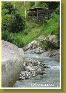 To get there you must travel though narrow winding roads within Puerto Rico´s karst countryside, through thick tropical forest all the way up to the highest and coolest part of the island. Although this town is about 30 miles away from San Juan by helicopter, it takes about two hours to reach this place from the San Juan Metro area by car.
The town of Jayaya is located within "La Cordillera Central" (central mountain range) of Puerto Rico. The name Jayuya comes from the Cacique (indian chief) Hayuya. This beautiful town, surrounded by the most picture perfect forests and mountains of Puerto Rico, was founded as a village in 1883 and in 1911 became a municipality.
The people of this wonderful country town, although immersed in modern-day culture, take incredible pride and love in the Puerto Rican heritage which is so alive here. This is probably due to the richness in aboriginal history and the many petroglyphs and indian artifacts found in this part of the island.
One of the most incredible and beautiful examples of this is "La Piedra Escrita". This giant boulder, found on the river bed of “El Rio Grande de Jayuya”, is carved with plenty of prehistoric petroglyphs.
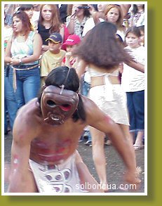 Every year (usually on the weekend closest to November 19th) Jayuya celebrates “El Festival Nacional Indigena”. This folkloric festival is an expression of love of our heritage and our Taino ancestors. The event includes indigenous dances and rituals performed by the lovely Jayuya youths of “Los Danzantes de la Tierra Alta” and “La Banda Indigena”. Other activities include selecting and parading an indigeous beauty queen, artisan crafts festival, live Puerto Rican music, expositions and plenty of Puerto Rican food and “frituras”.
Some of the highest mountains of Puerto Rico are found in this municipality. Cerro La Punta is the highest mountain in Puerto Rico. Its peak has an elevation of 1,338 meters (4,398 feet). Other very high peaks are El Monte Rosa, 1,267 meters; Monte Jayaya, 1,250 meters, and Los Tres Picachos, 1,205, just to mention a few. El Cerro Maravilla (1,183 meters) on road PR143 has the most spectacular and breathtaking view of the southern part of the island and the Caribbean Sea.
Due to the high elevation, daily temperatures are below those of the rest of the island. In Jayuya, the cool climate is about 10 degrees Fahrenheit lower than that of the coasts favoring the tomato, coffee, peas and vegetable crops which make up the local economy. Cattle farming and manufacturing also form part of Jayuya’s everyday life.
When in Jayuya you must visit:
- La Piedra Escrita – A huge petroglyph rock in the bed of “El Rio Grande de Jayuya”.
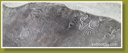 This monument of prehistoric Puerto Rico was left to us by our Taino ancestors who left us very valuable and interesting carvings known as “Petroglifos de Rio”. A boardwalk gives very easy access to the area plus the view of the surrounding forest is incredibly beautiful. It's a great place to go swimming Puerto Rican style on a family picnic. Road PR 144 Km 7.3
 - Casa Canales – Reconstructed in the '90s, this wooden house was originally built by Don Rosario Canales Quintero, founder and the first Mayor of Jayuya, in 1883. It is a typical Puerto Rican home made with woods native to the island and some imported materials. Today this house is a museum and a historical research center. Road PR 144
- Museo El Cemi – The architectural design of this museum is a giant “Cemi”, which is an earthly representation of the Taino divinities. Inside, an exhibit of Taino artifacts give evidence of our indigenous culture and heritage. Road PR 144
- Tumba del Indio Puertoriqueño – Here lie the remains of a Puerto Rican Indian who represents our Taino ancestors.
- Centro Cultural Jayuyano.
- Plaza de Recreo.
- Sightseeing the beautiful countryside. Enjoy!

COPYRIGHT© 2005-2011 William Figueroa
Reproduction of layout, images or articles is prohibited.
¡Que Lindo Es Puerto Rico!
¡PAZ!
DaY