
Geography of Puerto Rico
The Antilles
Puerto Rico is located in the archipelago of the Antilles. The Antilles is a chain of islands that stretch more than 1500 miles starting from Florida (USA) to Venezuela (South America). They enclose the Caribbean sea. To the north and east is the Atlantic Ocean.
The Antilles is divided into two, the Greater Antilles and the Lesser Antilles. Puerto Rico, Cuba, Jamaica together with the island of Hispanola (Haiti and the Dominican Republic) make up the Greater Antilles. These are the largest islands of the Antilles, Puerto Rico being the smallest of the four. The Lesser Antilles, located east and southeast of Puerto Rico, are made up of dozens of smaller islands, just to mention a few, the Virgin Islands, Montserrat, Guadeloupe, Dominica, Martinique, Barbados and Trinidad. Cultural and political diversity is typical throughout the region.
Geographical Areas of Puerto Rico
Puerto Rico is actually an archipelago of islands within the archipelago of the Antilles. The smaller nearby islands are also part of Puerto Rico. Two of them, Vieques and Culebra, are municipalities and most of the other small islands are used for wild life reserves and recreational areas.
The Main Island of Puerto Rico
Known as La Isla Grande,the main island of Puerto Rico has an area of 100 miles long by 35 miles wide. It is divided into three geographical areas:
- Central Interior Mountain Ranges
- Northern Karst
- Coastal Plains
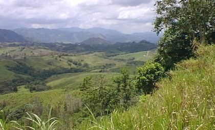
Central Interior Mountain Ranges
This area covers most of the island of Puerto Rico. It includes the interior mountains, hills, mountain sides, and low areas within the mountains. These mountain ranges are La Cordillera Central, La Sierra de Cayey, La Sierra de Luquillo, and La Sierra Bermeja.
La Cordillera Central extends from Aibonito (on the east) to Maricao (on the west). 35 km from the northern coast and 15 to 25 km from the south coast. Its highest peaks are located between Villalba and Adjuntas. These are Cerro La Puntita (4,389 ft) and Los Tres Picachos (3615 ft). Much more rain falls on the northern side of the mountain range as compared to the southern side. The northern side is much steeper than the southern side.
La Sierra de Cayey is an extension of La Cordillera Central. It extends from Cayey to Humacao. To the far east its elevation reaches a mere 400 ft. Two ramifications called Sierra Guardarraya and Cuchillas de Panduras extend southeast between Yabucoa and Maunabo.
From Gurabo to Fajardo, in the northeast we have La Sierra De Luquillo. El Yunque (cool tourist site) is one of its peaks (3,494 ft), El Toro (3524 ft) and El Pico Oeste (3416 ft) also happen to be up there.
Sierra Bermeja which extends from Guánica to the southwestern tip of the island, located south of El Valle de Lajas (largest valley in PR) is the smallest of the branches of the Central Mountain ranges. Its highest peaks reach 1000 ft.
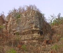
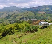
Northern Karst
Our Tropical Karst is located in the northern interior mountainous part of the island of Puerto Rico. This particular area consists of formations of limestone rock dissolved by water throughout the geological ages. This area is a plateau with elevations from 100-700 ft. The northern part is made up of limestone hills while the interior is pocketed with hills, holes and caves. Many caves here have not been completely explored. Some rivers, like El Río de Camuy, pass through this area disappear under the surface and reappear various kilometers down hill. It is the site of the Rio de Camuy Cave Park. The Arecibo Observatory, the worlds largest radio/telescope, is also located in this area.
Coastal Plains
The Coastal Plains are smaller in square miles than the Central Interior Mountain Ranges and the Northern Karst. This area, which is relatively flat, was originally formed by the erosion of the interior mountains. The largest cities on the island are located here, San Juan to the north, Ponce to the south and Mayaguez to the west. Beaches and sand dunes are abundant on Puerto Rico's 1,126 kilometers of coast.
The Island of Culebra
The municipality of Culebra is located 17 miles east of the main island of Puerto Rico. It has an area of 10 square miles. It is located in an excellent fishing area which contributes to the economy of this small island. Its arid soil is used for pasture and also to cultivate fruit which is consumed locally. Monte Resaca, is the highest mountain on the island. Other small islands near Culebra are: Isla Culebrita, Luis Peña, Cayo Norte, Lobo, Lobito, and more.
The Island of Vieques
The municipality of Vieques is located 8 miles east of Puerto Rico. It has an area of 52 square miles. Its highest peak is Monte Pirata, 1000 ft. high. The island has no rivers but has fertile soil. Two of the most populated areas of the island are Barrio Esperanza, on the southern part of the island and Isabel II to the north. City Hall and most government services are located here. One of the most unique beauties of Vieques is the Bio Luminescent Bay. Also Vieques has various lagoons. Fishing is an important economical activity.
Other Islands
To mention a few of the other islands of Puerto Rico we have: Isla Mona, Monito and Desecheo to the west and Recreational Area Caja de Muertos to the south. As mentioned before Puerto Rico is an archipelago of islands within the archipelago of the Antilles.
